
Make a donation
Gear up for your next adventure:
As an Amazon Associate, this site earns from qualifying purchases at no extra cost to you.
Remda topographic map
Click on the map to display elevation.
Make a donation
Gear up for your next adventure:
As an Amazon Associate, this site earns from qualifying purchases at no extra cost to you.
Remda
Die weitere Umgebung des Ortsteils ist im Süden von bewaldeten Buntsandsteinbergen und im Norden von steil ansteigenden Muschelkalkhöhen geprägt, die durch den Taleinschnitt der Remdaer Rinne voneinander getrennt werden. Südlich von Remda wachsen auf Buntsandstein eichenreiche Laubgehölze mit Massenbeständen an Maiglöckchen und Schattenblümchen. Die Waldränder zieren Hainwachtelweizen, Goldrute, Pechnelke, Heidenelke, Prachtnelke sowie vereinzelt Großblütiger Fingerhut und Fuchssche Kuckucksblume.
Make a donation
Gear up for your next adventure:
As an Amazon Associate, this site earns from qualifying purchases at no extra cost to you.
About this map
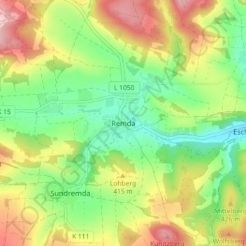
Name: Remda topographic map, elevation, terrain.
Average elevation: 383 m
Minimum elevation: 288 m
Maximum elevation: 513 m
Make a donation
Gear up for your next adventure:
As an Amazon Associate, this site earns from qualifying purchases at no extra cost to you.
Other topographic maps
Click on a map to view its topography, its elevation and its terrain.
Kanu Wandern auf der Saale
Deutschland > Thüringen > Landkreis Saalfeld-Rudolstadt > Rudolstadt > Oberpreilipp
Average elevation: 229 m