Geolocate

Dayapan topographic map

Click on the map to display elevation.

About this map

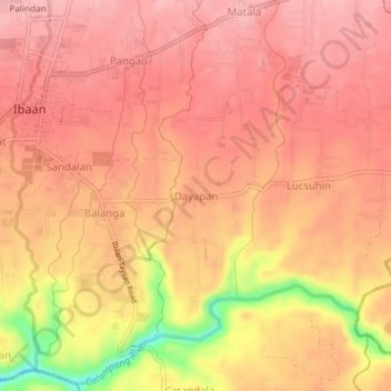
Name: Dayapan topographic map, elevation, terrain.

Location: Dayapan, Ibaan, Batangas, Calabarzon, 4230, Philippines (13.78961 121.12966 13.82961 121.16966)

Average elevation: 107 m

Minimum elevation: 14 m

Maximum elevation: 139 m

Other topographic maps

Click on a map to view its topography, its elevation and its terrain.

Calumpang River

Philippines > Batangas > Ibaan > Catandala

Average elevation: 93 m

Calumpang River

Philippines > Batangas > Ibaan

Average elevation: 99 m

Coliat

Philippines > Batangas > Ibaan

Average elevation: 113 m

Talaibon

Philippines > Batangas > Ibaan

Average elevation: 142 m

Calumpang River

Philippines > Batangas > Ibaan > Balanga

Average elevation: 84 m

Pangao

Philippines > Batangas > Ibaan

Average elevation: 130 m

Palindan

Philippines > Batangas > Ibaan

Average elevation: 134 m

Taysan River

Philippines > Batangas > Ibaan > Salaban Ⅱ

Average elevation: 139 m

Balanga

Philippines > Batangas > Ibaan

Average elevation: 93 m

Calumpang River

Philippines > Batangas > Ibaan > Balanga

Average elevation: 84 m

Pangao

Philippines > Batangas > Ibaan

Average elevation: 130 m

Gear up for your next adventure:

🔥Camping Stove - Portable stoves to cook outdoors with ease
🥾Mountain Hiking Boots - High-traction boots for rocky terrain
🔭Compact Monocular - One-handed bird watching and trail spotting
🥤Collapsible Travel Cup - Saves space and weight in your mess kit
🧴Insect Repellent - Protect yourself from bugs during outdoor adventures

As an Amazon Associate, this site earns from qualifying purchases at no extra cost to you.