
Harvard topographic map
Click on the map to display elevation.
Harvard
The eastern part of Harvard is on a large ridgeline. In 1931 Harvard College established the Oak Ridge Observatory at an elevation of 609 feet on Pinnacle Rd, the highest point between Mount Wachusett and the ocean.
About this map
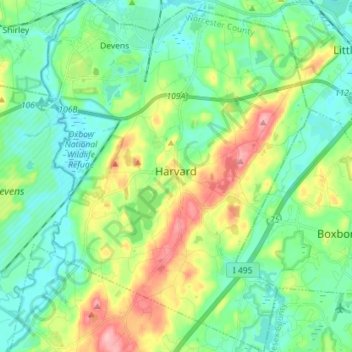
Name: Harvard topographic map, elevation, terrain.
Location: Harvard, Worcester County, Massachusetts, United States (42.44732 -71.63921 42.55250 -71.52984)
Average elevation: 100 m
Minimum elevation: 61 m
Maximum elevation: 194 m
Other topographic maps
Click on a map to view its topography, its elevation and its terrain.
Wachusett Station
United States > Massachusetts > Worcester County > Fitchburg
Average elevation: 229 m
Central (Stanley) Woolen Mill District Park
United States > Massachusetts > Worcester County > Uxbridge
Average elevation: 80 m
Crow Hill Ledges
United States > Massachusetts > Worcester County > Westminster
Average elevation: 293 m
Olde English Village
United States > Massachusetts > Worcester County > Gardner
Average elevation: 308 m
Vernon Hill
United States > Massachusetts > Worcester County > Worcester > Quinsigamond Village
Average elevation: 162 m
South Charlton Reservoir
United States > Massachusetts > Worcester County > Charlton > South Charlton
Average elevation: 203 m
Tatnuck
United States > Massachusetts > Worcester County > Worcester > Tatnuck Square
Average elevation: 221 m
Blackburn Village
United States > Massachusetts > Worcester County > Ashburnham
Average elevation: 326 m
Hadwen Park
United States > Massachusetts > Worcester County > Worcester > Heard Street
Average elevation: 166 m
Institute Park
United States > Massachusetts > Worcester County > Worcester > Belmont Hill
Average elevation: 170 m
Thompsons Pond Dam
United States > Massachusetts > Worcester County > Spencer
Average elevation: 278 m
Phillipston Four Corners
United States > Massachusetts > Worcester County > Phillipston
Average elevation: 335 m
Northbridge Center
United States > Massachusetts > Worcester County > Northbridge
Average elevation: 124 m
West Upton
United States > Massachusetts > Worcester County > Upton > West Upton
Average elevation: 111 m
Jefferson
United States > Massachusetts > Worcester County > Holden > Jefferson
Average elevation: 248 m