
Dohan topographic map
Interactive map
Click on the map to display elevation.
About this map
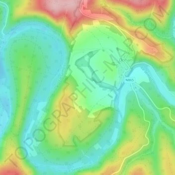
Name: Dohan topographic map, elevation, terrain.
Location: Dohan, Bouillon, Neufchâteau, Luxembourg, Wallonie, Belgique (49.77870 5.11528 49.80675 5.16091)
Average elevation: 284 m
Minimum elevation: 220 m
Maximum elevation: 400 m
Other topographic maps
Click on a map to view its topography, its elevation and its terrain.
Corbion
Belgique > Luxembourg > Neufchâteau > Bouillon
Corbion, Bouillon, Neufchâteau, Luxembourg, Wallonie, 6838, Belgique
Average elevation: 344 m
Le Tombeau du Géant
Belgique > Luxembourg > Neufchâteau > Bouillon > Ucimont > Botassart
Le Tombeau du Géant, Moulin du Rivage, Botassart, Ucimont, Bouillon, Neufchâteau, Luxembourg, Wallonie, 6833, Belgique
Average elevation: 300 m
Sensenruth
Belgique > Luxembourg > Neufchâteau > Bouillon
Sensenruth, Bouillon, Neufchâteau, Luxembourg, Wallonie, 6832, Belgique
Average elevation: 358 m
Bouillon
Belgique > Luxembourg > Neufchâteau > Bouillon
Bouillon, Neufchâteau, Luxembourg, Wallonie, 6830, Belgique
Average elevation: 338 m
Frahan
Belgique > Luxembourg > Neufchâteau > Bouillon > Rochehaut
Frahan, Rochehaut, Bouillon, Neufchâteau, Luxembourg, Wallonie, 6838, Belgique
Average elevation: 291 m
Rochehaut
Belgique > Luxembourg > Neufchâteau > Bouillon
Rochehaut, Bouillon, Neufchâteau, Luxembourg, Wallonie, Belgique
Average elevation: 296 m
Cordemois
Belgique > Luxembourg > Neufchâteau > Bouillon
Cordemois, Bouillon, Neufchâteau, Luxembourg, Wallonie, 6830, Belgique
Average elevation: 312 m
Curfoz
Belgique > Luxembourg > Neufchâteau > Bouillon
Curfoz, Bouillon, Neufchâteau, Luxembourg, Wallonie, 6831, Belgique
Average elevation: 344 m
Briahan
Belgique > Luxembourg > Neufchâteau > Bouillon
Briahan, Sensenruth, Bouillon, Neufchâteau, Luxembourg, Wallonie, 6832, Belgique
Average elevation: 363 m