
Caldas Novas topographic map
Click on the map to display elevation.
Caldas Novas
The most important study about the thermal ism of Caldas Novas and the Rio Quente was carried out by the state enterprise Furnas Centrais Elétricas, due to the possible influence of the Usina Hidrelétrica Corumbá I dam on the thermal water table of the region, which would be under the risk of cooling. According to Furnas, the phenomenon of the hot water is produced by peculiar geological and topographic characteristics. For years it was thought that a volcano had existed in the area in whose crater rainwater infiltrated, heating at great depths and then returning to the surface by way of cracks in the rock. More modern studies show that there is no indication of volcanic activity in the region. Studies show that the water is formed by rainfall that is stored in a layer of quartzite and due to pressure is sent to the surface in a column 600 meters.
About this map
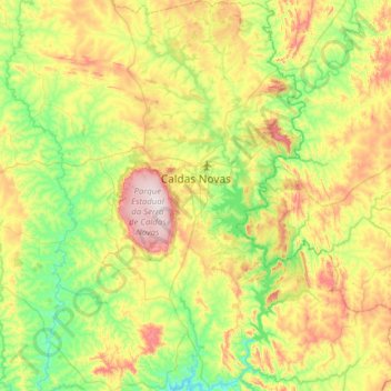
Name: Caldas Novas topographic map, elevation, terrain.
Average elevation: 694 m
Minimum elevation: 510 m
Maximum elevation: 1,046 m