
Make a donation
Gear up for your next adventure:
As an Amazon Associate, this site earns from qualifying purchases at no extra cost to you.
Pfaffenwiesbach topographic map
Click on the map to display elevation.
Make a donation
Gear up for your next adventure:
As an Amazon Associate, this site earns from qualifying purchases at no extra cost to you.
Pfaffenwiesbach
Von mehreren Brunnen, die es einst in Pfaffenwiesbach gab (früher gab es beispielsweise noch einen unterhalb der Georgskirche), existiert leider nur noch einer: der in der Höhenstraße. An der Kreuzung Pfingstbornstraße/Lerchenstraße befindet sich der Pfingstborn – eine Quelleinfassung, die heute liebevoll als Ruheplatz gestaltet ist.
Make a donation
Gear up for your next adventure:
As an Amazon Associate, this site earns from qualifying purchases at no extra cost to you.
About this map
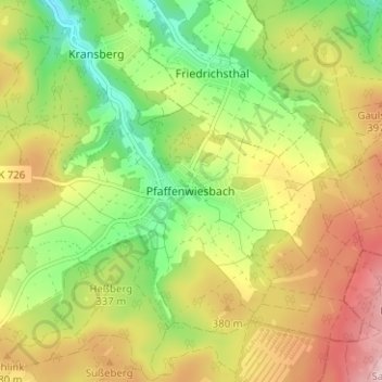
Name: Pfaffenwiesbach topographic map, elevation, terrain.
Average elevation: 343 m
Minimum elevation: 234 m
Maximum elevation: 467 m
Make a donation
Gear up for your next adventure:
As an Amazon Associate, this site earns from qualifying purchases at no extra cost to you.