
Make a donation
Gear up for your next adventure:
As an Amazon Associate, this site earns from qualifying purchases at no extra cost to you.
Wehrheim topographic map
Click on the map to display elevation.
Make a donation
Gear up for your next adventure:
As an Amazon Associate, this site earns from qualifying purchases at no extra cost to you.
Wehrheim
Wehrheim liegt in 305 bis 400 Meter Höhe im östlichen Hintertaunus am Nordhang des Taunushauptkamms zwischen Bad Homburg vor der Höhe und Usingen. Die Südgrenze des Stadtgebietes und teilweise auch der Gemarkung Wehrheim bildet der Limes. In den Wäldern südlich der Kerngemeinde liegt die Schanze Lochmühle, eine Wallanlage, die aufgrund fehlender Funde noch nicht datiert werden konnte.
Make a donation
Gear up for your next adventure:
As an Amazon Associate, this site earns from qualifying purchases at no extra cost to you.
About this map
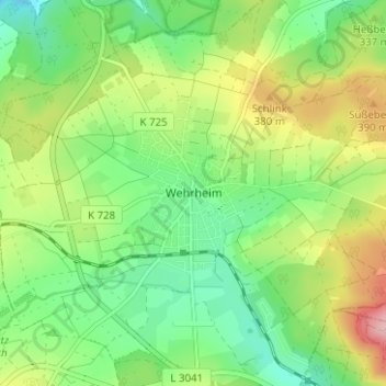
Name: Wehrheim topographic map, elevation, terrain.
Location: Wehrheim, Hochtaunuskreis, Hessen, 61273, Deutschland (50.28266 8.54888 50.32266 8.58888)
Average elevation: 337 m
Minimum elevation: 275 m
Maximum elevation: 443 m
Make a donation
Gear up for your next adventure:
As an Amazon Associate, this site earns from qualifying purchases at no extra cost to you.