
Make a donation
Gear up for your next adventure:
As an Amazon Associate, this site earns from qualifying purchases at no extra cost to you.
Neu-Anspach topographic map
Click on the map to display elevation.
Make a donation
Gear up for your next adventure:
As an Amazon Associate, this site earns from qualifying purchases at no extra cost to you.
Neu-Anspach
Neu-Anspach liegt in 300 bis 400 Meter Höhe nördlich des östlichen Taunuskamms in einer weiträumigen Senke des Usatals. Auf dem Gebiet von Neu-Anspach verlaufen folgende Bäche, die alle in die Usa fließen: Ansbach, Heisterbach, Arnsbach, Forstbach, Röderbach, Häuserbach und Eisenbach.
Make a donation
Gear up for your next adventure:
As an Amazon Associate, this site earns from qualifying purchases at no extra cost to you.
About this map
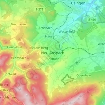
Name: Neu-Anspach topographic map, elevation, terrain.
Location: Neu-Anspach, Hochtaunuskreis, Hessen, 61267, Deutschland (50.25626 8.46661 50.33626 8.54661)
Average elevation: 404 m
Minimum elevation: 256 m
Maximum elevation: 638 m
Make a donation
Gear up for your next adventure:
As an Amazon Associate, this site earns from qualifying purchases at no extra cost to you.
Other topographic maps
Click on a map to view its topography, its elevation and its terrain.
Westerfeld
Deutschland > Hessen > Hochtaunuskreis > Neu-Anspach > Neu-Anspach
Average elevation: 323 m