
Make a donation
Gear up for your next adventure:
As an Amazon Associate, this site earns from qualifying purchases at no extra cost to you.
Zelenograd topographic map
Click on the map to display elevation.
Make a donation
Gear up for your next adventure:
As an Amazon Associate, this site earns from qualifying purchases at no extra cost to you.
About this map
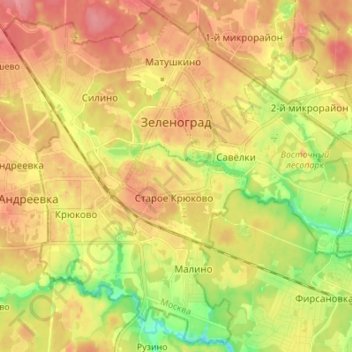
Name: Zelenograd topographic map, elevation, terrain.
Location: Zelenograd, Moscow, Central Federal District, Russia (55.94801 37.13160 56.02122 37.26830)
Average elevation: 205 m
Minimum elevation: 162 m
Maximum elevation: 238 m
Make a donation
Gear up for your next adventure:
As an Amazon Associate, this site earns from qualifying purchases at no extra cost to you.
Other topographic maps
Click on a map to view its topography, its elevation and its terrain.
Moscow
Moscow is situated on the banks of the Moskva River, which flows for just over 500 km (311 mi) through the East European Plain in central Russia, not far from the natural border of the forest and forest-steppe zone. 49 bridges span the river and its canals within the city's limits. The elevation of Moscow at…
Average elevation: 159 m