
Make a donation
Gear up for your next adventure:
As an Amazon Associate, this site earns from qualifying purchases at no extra cost to you.
Carreiras topographic map
Click on the map to display elevation.
Make a donation
Gear up for your next adventure:
As an Amazon Associate, this site earns from qualifying purchases at no extra cost to you.
About this map
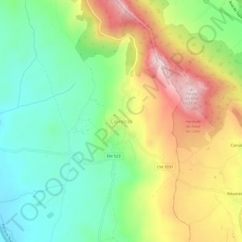
Name: Carreiras topographic map, elevation, terrain.
Location: Carreiras, Portalegre, 7300-355, Portugal (39.35200 -7.45223 39.39200 -7.41223)
Average elevation: 574 m
Minimum elevation: 403 m
Maximum elevation: 828 m
Make a donation
Gear up for your next adventure:
As an Amazon Associate, this site earns from qualifying purchases at no extra cost to you.
Other topographic maps
Click on a map to view its topography, its elevation and its terrain.
Alegrete
Portugal > Portalegre > Portalegre
Inserida em pleno Parque Natural da Serra de São Mamede, a uma altitude de 500 m, localiza-se a cerca de 2 km da margem direita da ribeira de Alegrete, caracterizada por uma enorme diversidade geológica, paisagística, faunística e florística.
Average elevation: 492 m
Make a donation
Gear up for your next adventure:
As an Amazon Associate, this site earns from qualifying purchases at no extra cost to you.
Make a donation
Gear up for your next adventure:
As an Amazon Associate, this site earns from qualifying purchases at no extra cost to you.