
Thank you for supporting this site ❤️
Make a donation
Make a donation
Gear up for your next adventure:
As an Amazon Associate, this site earns from qualifying purchases at no extra cost to you.
Beden topographic map
Click on the map to display elevation.
Thank you for supporting this site ❤️
Make a donation
Make a donation
Gear up for your next adventure:
As an Amazon Associate, this site earns from qualifying purchases at no extra cost to you.
About this map
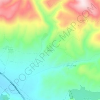
Name: Beden topographic map, elevation, terrain.
Location: Beden, Gümüşhacıköy, Amasya, Région de la mer Noire, Turquie (40.91806 35.16324 40.95806 35.20324)
Average elevation: 1,054 m
Minimum elevation: 885 m
Maximum elevation: 1,358 m
Thank you for supporting this site ❤️
Make a donation
Make a donation
Gear up for your next adventure:
As an Amazon Associate, this site earns from qualifying purchases at no extra cost to you.