
Make a donation
Gear up for your next adventure:
As an Amazon Associate, this site earns from qualifying purchases at no extra cost to you.
La Favière topographic map
Click on the map to display elevation.
Make a donation
Gear up for your next adventure:
As an Amazon Associate, this site earns from qualifying purchases at no extra cost to you.
About this map
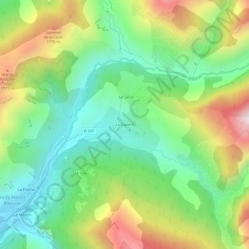
Name: La Favière topographic map, elevation, terrain.
Average elevation: 1,404 m
Minimum elevation: 1,027 m
Maximum elevation: 2,042 m
Make a donation
Gear up for your next adventure:
As an Amazon Associate, this site earns from qualifying purchases at no extra cost to you.
Other topographic maps
Click on a map to view its topography, its elevation and its terrain.
Mariaud
France > Provence-Alpes-Côte d'Azur > Alpes-de-Haute-Provence > Prads-Haute-Bléone
Average elevation: 1,727 m
Blégiers
France > Provence-Alpes-Côte d'Azur > Alpes-de-Haute-Provence > Prads-Haute-Bléone
Average elevation: 1,426 m
Prads
France > Provence-Alpes-Côte d'Azur > Alpes-de-Haute-Provence > Prads-Haute-Bléone
Average elevation: 1,788 m