
Make a donation
Gear up for your next adventure:
As an Amazon Associate, this site earns from qualifying purchases at no extra cost to you.
Nago-Torbole topographic map
Click on the map to display elevation.
Make a donation
Gear up for your next adventure:
As an Amazon Associate, this site earns from qualifying purchases at no extra cost to you.
About this map
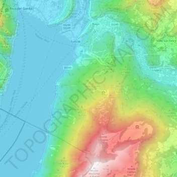
Name: Nago-Torbole topographic map, elevation, terrain.
Average elevation: 587 m
Minimum elevation: 53 m
Maximum elevation: 2,073 m
Make a donation
Gear up for your next adventure:
As an Amazon Associate, this site earns from qualifying purchases at no extra cost to you.
Other topographic maps
Click on a map to view its topography, its elevation and its terrain.
Make a donation
Gear up for your next adventure:
As an Amazon Associate, this site earns from qualifying purchases at no extra cost to you.
Santa Maria di Laghel
Italië > Trentino-Zuid-Tirol > Provincia di Trento > Arco > San Martino
Average elevation: 279 m
Make a donation
Gear up for your next adventure:
As an Amazon Associate, this site earns from qualifying purchases at no extra cost to you.
Campo Carlo Magno
Italië > Trentino-Zuid-Tirol > Provincia di Trento > Pinzolo
Average elevation: 1,777 m
Karerpass - Jouf de Ciareja - passo Carezza
Italië > Trentino-Zuid-Tirol > Provincia di Trento
Average elevation: 1,869 m
Make a donation
Gear up for your next adventure:
As an Amazon Associate, this site earns from qualifying purchases at no extra cost to you.
Cima Venezia - Veneziaspitze
Italië > Trentino-Zuid-Tirol > Provincia di Trento > Peio
Average elevation: 3,037 m
Candriai
Italië > Trentino-Zuid-Tirol > Provincia di Trento > Trente > Sardagna
Average elevation: 744 m
Make a donation
Gear up for your next adventure:
As an Amazon Associate, this site earns from qualifying purchases at no extra cost to you.
Belvedere
Italië > Trentino-Zuid-Tirol > Provincia di Trento > Trente > Ravina
Average elevation: 496 m
Make a donation
Gear up for your next adventure:
As an Amazon Associate, this site earns from qualifying purchases at no extra cost to you.
Make a donation
Gear up for your next adventure:
As an Amazon Associate, this site earns from qualifying purchases at no extra cost to you.
Soraga
Italië > Trentino-Zuid-Tirol > Provincia di Trento > Soraga di Fassa
Average elevation: 1,508 m
Make a donation
Gear up for your next adventure:
As an Amazon Associate, this site earns from qualifying purchases at no extra cost to you.
Val di Fiemme
Italië > Trentino-Zuid-Tirol > Provincia di Trento > Predazzo
Average elevation: 1,637 m
Make a donation
Gear up for your next adventure:
As an Amazon Associate, this site earns from qualifying purchases at no extra cost to you.
Coroni
Italië > Trentino-Zuid-Tirol > Provincia di Trento > Canal San Bovo > Prade
Average elevation: 984 m
Mitterpèrg - San Felice
Italië > Trentino-Zuid-Tirol > Provincia di Trento > Mitterpèrg - San Felice
Average elevation: 1,288 m
Canazei
Italië > Trentino-Zuid-Tirol > Provincia di Trento > Canazei > Canazei
Average elevation: 1,823 m
Make a donation
Gear up for your next adventure:
As an Amazon Associate, this site earns from qualifying purchases at no extra cost to you.
Vigo di Fassa
Italië > Trentino-Zuid-Tirol > Provincia di Trento > Vigo di Fassa
Average elevation: 1,600 m
Rif dei Canacéi
Italië > Trentino-Zuid-Tirol > Provincia di Trento > Predazzo
Average elevation: 1,718 m
Cave di Brione
Italië > Trentino-Zuid-Tirol > Provincia di Trento > Riva del Garda > Sant'Alessandro
Average elevation: 99 m
Make a donation
Gear up for your next adventure:
As an Amazon Associate, this site earns from qualifying purchases at no extra cost to you.