
Make a donation
Gear up for your next adventure:
As an Amazon Associate, this site earns from qualifying purchases at no extra cost to you.
El Calafate topographic map
Click on the map to display elevation.
Make a donation
Gear up for your next adventure:
As an Amazon Associate, this site earns from qualifying purchases at no extra cost to you.
El Calafate
The most recent World Altitude Gliding record of 22,657 m (74,333 ft) was set near El Calafate on 2 September 2018 by Jim Payne and Tim Gardner in the new Perlan 2 glider (with pressurised cabin).
Make a donation
Gear up for your next adventure:
As an Amazon Associate, this site earns from qualifying purchases at no extra cost to you.
About this map
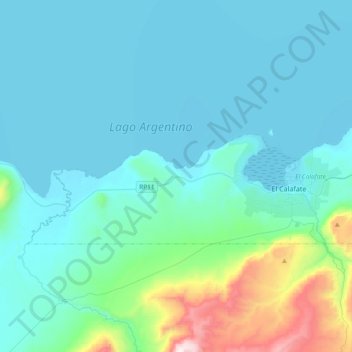
Name: El Calafate topographic map, elevation, terrain.
Average elevation: 432 m
Minimum elevation: 177 m
Maximum elevation: 1,508 m
Make a donation
Gear up for your next adventure:
As an Amazon Associate, this site earns from qualifying purchases at no extra cost to you.
Other topographic maps
Click on a map to view its topography, its elevation and its terrain.
Make a donation
Gear up for your next adventure:
As an Amazon Associate, this site earns from qualifying purchases at no extra cost to you.