Geolocate

Natatas topographic map

Click on the map to display elevation.

About this map

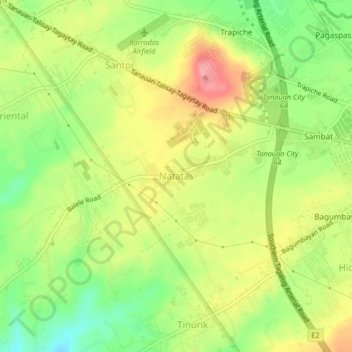
Name: Natatas topographic map, elevation, terrain.

Location: Natatas, Tanauan, Batangas, Calabarzon, 4232, Philippines (14.06086 121.10006 14.10086 121.14006)

Average elevation: 150 m

Minimum elevation: 99 m

Maximum elevation: 202 m

Other topographic maps

Click on a map to view its topography, its elevation and its terrain.

Maria Paz

Philippines > Batangas > Tanauan

Average elevation: 64 m

Barangay 3

Philippines > Batangas > Tanauan > Hidalgo

Average elevation: 158 m

Barangay 5

Philippines > Batangas > Tanauan > Hidalgo

Average elevation: 154 m

Barangay 5

Philippines > Batangas > Tanauan > Hidalgo

Average elevation: 154 m

Suplang

Philippines > Batangas > Tanauan

Average elevation: 247 m

Gear up for your next adventure:

🧢Beanie Hat - Keep your head warm in cold weather
Tent Footprint - Protect tent floor and increase durability
🛶Waterproof Dry Bags - Keep electronics and clothes dry during river crossings
🧰Survival Kit - Essential gear for emergencies in the wilderness
👖Convertible Hiking Pants - Zip-off legs to adapt to changing weather conditions

As an Amazon Associate, this site earns from qualifying purchases at no extra cost to you.