
Make a donation
Gear up for your next adventure:
As an Amazon Associate, this site earns from qualifying purchases at no extra cost to you.
Liebenburg topographic map
Click on the map to display elevation.
Make a donation
Gear up for your next adventure:
As an Amazon Associate, this site earns from qualifying purchases at no extra cost to you.
Liebenburg
Liebenburg liegt am östlichen Rand des südlichen Salzgitter-Höhenzugs im nördlichen Harzvorland zwischen Salzgitter-Bad und Schladen-Werla am 210 m hohen Burgberg. Durch den Ort fließt der Stobenbergbach, ein Nebenbach der Warne. Die nächstgelegenen Städte sind Goslar, Salzgitter und Wolfenbüttel.
Make a donation
Gear up for your next adventure:
As an Amazon Associate, this site earns from qualifying purchases at no extra cost to you.
About this map
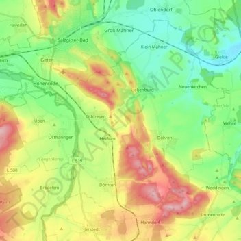
Name: Liebenburg topographic map, elevation, terrain.
Average elevation: 173 m
Minimum elevation: 90 m
Maximum elevation: 310 m
Make a donation
Gear up for your next adventure:
As an Amazon Associate, this site earns from qualifying purchases at no extra cost to you.
Other topographic maps
Click on a map to view its topography, its elevation and its terrain.
Kaiserpfalz Goslar
Deutschland > Niedersachsen > Landkreis Goslar > Goslar
Die Ursprünge der Kaiserpfalz liegen vermutlich in einem königlichen Jagdhof, wie ihn Adam von Bremen für die ottonische Zeit erwähnte. Bereits Heinrich II. hatte um 1005 einen ersten Pfalzbau in Goslar errichten lassen, der, sicher aufgrund der reichen Erzfunde des nahen Rammelsbergs, der unweit gelegenen…
Average elevation: 323 m