
Thank you for supporting this site ❤️
Make a donation
Make a donation
Gear up for your next adventure:
As an Amazon Associate, this site earns from qualifying purchases at no extra cost to you.
Hendrik-Ido-Ambacht topographic map
Click on the map to display elevation.
Thank you for supporting this site ❤️
Make a donation
Make a donation
Gear up for your next adventure:
As an Amazon Associate, this site earns from qualifying purchases at no extra cost to you.
Hendrik-Ido-Ambacht
Dutch topographic map of the municipality of Hendrik-Ido-Ambacht, June 2015
Thank you for supporting this site ❤️
Make a donation
Make a donation
Gear up for your next adventure:
As an Amazon Associate, this site earns from qualifying purchases at no extra cost to you.
About this map
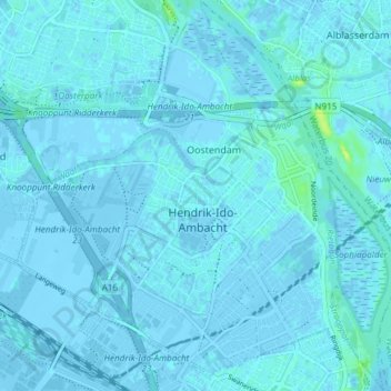
Name: Hendrik-Ido-Ambacht topographic map, elevation, terrain.
Location: Hendrik-Ido-Ambacht, South Holland, Netherlands (51.82359 4.60016 51.86985 4.67270)
Average elevation: 1 m
Minimum elevation: -5 m
Maximum elevation: 14 m
Thank you for supporting this site ❤️
Make a donation
Make a donation
Gear up for your next adventure:
As an Amazon Associate, this site earns from qualifying purchases at no extra cost to you.