
Thank you for supporting this site ❤️
Make a donation
Make a donation
Gear up for your next adventure:
As an Amazon Associate, this site earns from qualifying purchases at no extra cost to you.
Crowland topographic map
Click on the map to display elevation.
Thank you for supporting this site ❤️
Make a donation
Make a donation
Gear up for your next adventure:
As an Amazon Associate, this site earns from qualifying purchases at no extra cost to you.
About this map
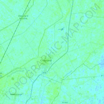
Name: Crowland topographic map, elevation, terrain.
Location: Crowland, South Holland, Lincolnshire, England, United Kingdom (52.65149 -0.23529 52.71808 -0.05121)
Average elevation: 3 m
Minimum elevation: -2 m
Maximum elevation: 7 m
Thank you for supporting this site ❤️
Make a donation
Make a donation
Gear up for your next adventure:
As an Amazon Associate, this site earns from qualifying purchases at no extra cost to you.
Other topographic maps
Click on a map to view its topography, its elevation and its terrain.
Moulton Chapel
United Kingdom > England > Lincolnshire > South Holland > Moulton Chapel
Average elevation: 3 m