
Make a donation
Gear up for your next adventure:
As an Amazon Associate, this site earns from qualifying purchases at no extra cost to you.
Kluisberg topographic map
Click on the map to display elevation.
Make a donation
Gear up for your next adventure:
As an Amazon Associate, this site earns from qualifying purchases at no extra cost to you.
Kluisberg
De Kluisberg via de zijde Ruien is tevens opgenomen in de recreatieve fietsroutes de LF Vlaanderenroute, LF Heuvelroute en RV8a, deze routes komen op de top op 141 meter hoogte. De Route des Collines gaat ook over deze helling, net als de blauwe lus van de Ronde van Vlaanderenroute (zijde Orroir).
Make a donation
Gear up for your next adventure:
As an Amazon Associate, this site earns from qualifying purchases at no extra cost to you.
About this map
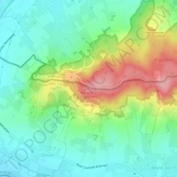
Name: Kluisberg topographic map, elevation, terrain.
Average elevation: 57 m
Minimum elevation: 11 m
Maximum elevation: 145 m
Make a donation
Gear up for your next adventure:
As an Amazon Associate, this site earns from qualifying purchases at no extra cost to you.