Geolocate

Llachon topographic map

Click on the map to display elevation.

About this map

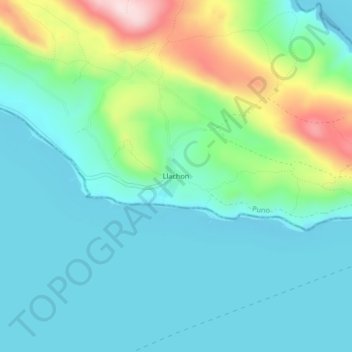
Name: Llachon topographic map, elevation, terrain.

Location: Llachon, Capachica, Puno, 21125, Perú (-15.74292 -69.80393 -15.70292 -69.76393)

Average elevation: 3,885 m

Minimum elevation: 3,805 m

Maximum elevation: 4,134 m

Gear up for your next adventure:

🛶Kayak Dry Bag - Waterproof storage for kayaking adventures
🥾Mountain Hiking Boots - High-traction boots for rocky terrain
🥾Trekking Poles - Adjustable trekking poles to reduce knee stress and improve stability
💡Portable Camping Lamp - Rechargeable lamp for campsite lighting
🧊Portable Cooler - Keep food and drinks cold during outdoor adventures

As an Amazon Associate, this site earns from qualifying purchases at no extra cost to you.