
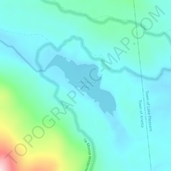
Little Moose Lake topographic map
Interactive map
Click on the map to display elevation.
About this map
Name: Little Moose Lake topographic map, elevation, terrain.
Average elevation: 699 m
Minimum elevation: 634 m
Maximum elevation: 1,000 m
Other topographic maps
Click on a map to view its topography, its elevation and its terrain.
Indian Lake
États-Unis > New York > Indian Lake
Indian Lake, Town of Indian Lake, Hamilton County, New York, 12842, États-Unis
Average elevation: 525 m
Westerlo
États-Unis > New York > Westerlo
Westerlo, Town of Westerlo, Albany County, New York, 12193, États-Unis
Average elevation: 381 m
Lyons Falls
États-Unis > New York > Lyons Falls
Lyons Falls, Lewis County, New York, 13368, États-Unis
Average elevation: 276 m
Peter Detmold Park Dog Run
États-Unis > New York > New York
Peter Detmold Park Dog Run, Turtle Bay, Manhattan Community Board 6, Manhattan, New York County, New York, États-Unis
Average elevation: 14 m
Todt Hill
États-Unis > New York > New York
Todt Hill, Staten Island, Richmond County, New York, 10304, États-Unis
Average elevation: 75 m
Niagara Falls
États-Unis > New York > Niagara Falls
Niagara Falls, Niagara County, New York, États-Unis
Average elevation: 180 m