
Baracoa topographic map
Interactive map
Click on the map to display elevation.
About this map
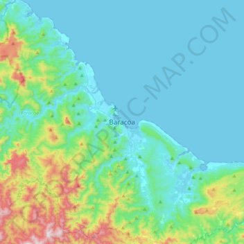
Name: Baracoa topographic map, elevation, terrain.
Location: Baracoa, Guantánamo, 97310, Cuba (20.18779 -74.65686 20.50779 -74.33686)
Average elevation: 153 m
Minimum elevation: -1 m
Maximum elevation: 900 m
Other topographic maps
Click on a map to view its topography, its elevation and its terrain.
Río Toa
Cuba > Guantánamo > Baracoa > Juncal
Río Toa, Juncal, Baracoa, Guantánamo, Cuba
Average elevation: 106 m