Geolocate

Littlemore topographic map

Click on the map to display elevation.

About this map

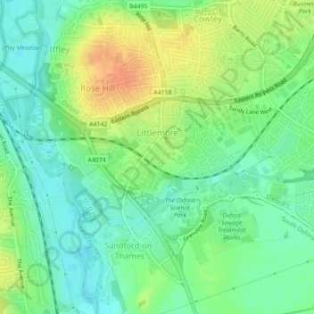
Name: Littlemore topographic map, elevation, terrain.

Location: Littlemore, Oxford, Oxfordshire, England, United Kingdom (51.71098 -1.23404 51.72789 -1.20642)

Average elevation: 67 m

Minimum elevation: 50 m

Maximum elevation: 91 m

Other topographic maps

Click on a map to view its topography, its elevation and its terrain.

Oxford

United Kingdom > England > Oxfordshire > Oxford

Average elevation: 81 m

Gear up for your next adventure:

🧦Crew Hiking Socks - Comfortable socks for long-distance hikes
🛶Waterproof Dry Bags - Keep electronics and clothes dry during river crossings
🌬️Windproof Camp Stove - Efficient cooking even on exposed mountain peaks
🕯️Camping Lantern - Illuminates your entire campsite with high-efficiency LEDs
🧣Merino Neck Gaiter - Protects against wind, sun, and cold at high altitudes

As an Amazon Associate, this site earns from qualifying purchases at no extra cost to you.