Geolocate

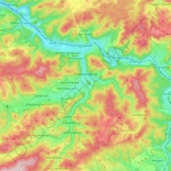
Plettenberg topographic map

Click on the map to display elevation.

Plettenberg

Plettenberg is located to the west of the Sauerland hills. The highest elevation of the town area is in the Ebbe Mountains with 663 m above sea level, the lowest elevation with 194 m near Teindeln [de]. The town is spread out between the four valleys of the rivers Lenne, Else, Oester [arz; ceb; cv; de; zh] and Grüne [ceb].

Wikipedia (CC-BY-SA 3.0)

About this map

Name: Plettenberg topographic map, elevation, terrain.

Location: Plettenberg, Märkischer Kreis, North Rhine-Westphalia, 58840, Germany (51.15236 7.76717 51.25919 7.95129)

Average elevation: 378 m

Minimum elevation: 186 m

Maximum elevation: 630 m

Gear up for your next adventure:

🥾Hiking Boots - Sturdy boots providing ankle support and traction on rugged trails
💧Reusable Water Bottle - Durable water bottles for hydration on trails
🧢Sun Protection Cap - Breathable cap to protect from sun exposure
🔋Lithium AA Batteries - Long-lasting power that performs in extreme cold
⛺Camping Tent - Weather-resistant tents suitable for 2 to 6 people

As an Amazon Associate, this site earns from qualifying purchases at no extra cost to you.