
Make a donation
Gear up for your next adventure:
As an Amazon Associate, this site earns from qualifying purchases at no extra cost to you.
Gold Bar topographic map
Click on the map to display elevation.
Make a donation
Gear up for your next adventure:
As an Amazon Associate, this site earns from qualifying purchases at no extra cost to you.
Gold Bar
Gold Bar is known as a white-water rafting destination for those seeking to float the Skykomish River. One of the most popular low elevation hikes in the metro Seattle area, the trail to Wallace Falls, is located on the north margin of the city. More than 160,000 people visit Wallace Falls State Park annually.
Make a donation
Gear up for your next adventure:
As an Amazon Associate, this site earns from qualifying purchases at no extra cost to you.
About this map
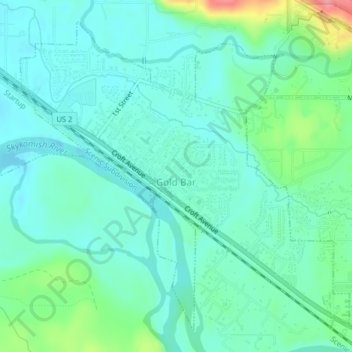
Name: Gold Bar topographic map, elevation, terrain.
Average elevation: 67 m
Minimum elevation: 46 m
Maximum elevation: 138 m
Make a donation
Gear up for your next adventure:
As an Amazon Associate, this site earns from qualifying purchases at no extra cost to you.