
Make a donation
Gear up for your next adventure:
As an Amazon Associate, this site earns from qualifying purchases at no extra cost to you.
Sötenich topographic map
Click on the map to display elevation.
Make a donation
Gear up for your next adventure:
As an Amazon Associate, this site earns from qualifying purchases at no extra cost to you.
Sötenich
Anstois | Benenberg | Diefenbach | Dottel | Frohnrath | Gillenberg | Golbach | Kall | Keldenich | Krekel | Rinnen | Roder | Rüth | Scheven | Sistig | Sötenich | Steinfeld | Steinfelderheistert | Straßbüsch | Urft | Wahlen | Wallenthal | Wallenthalerhöhe
Make a donation
Gear up for your next adventure:
As an Amazon Associate, this site earns from qualifying purchases at no extra cost to you.
About this map
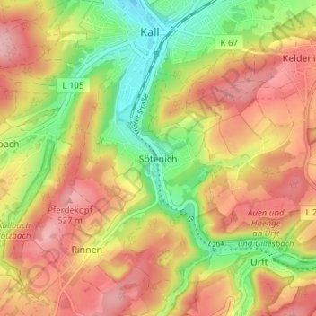
Name: Sötenich topographic map, elevation, terrain.
Average elevation: 458 m
Minimum elevation: 369 m
Maximum elevation: 533 m
Make a donation
Gear up for your next adventure:
As an Amazon Associate, this site earns from qualifying purchases at no extra cost to you.
Other topographic maps
Click on a map to view its topography, its elevation and its terrain.
Sistiger Heide
Deutschland > Nordrhein-Westfalen > Kreis Euskirchen > Kall > Benenberg
Average elevation: 570 m