Geolocate

Dundee topographic map

Click on the map to display elevation.

About this map

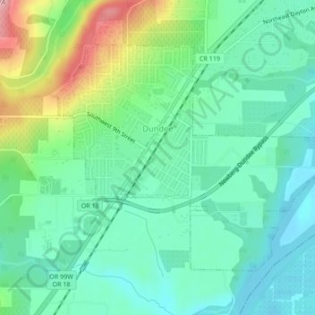
Name: Dundee topographic map, elevation, terrain.

Location: Dundee, Yamhill County, Oregon, 97115, United States (45.26464 -123.02493 45.28614 -122.98250)

Average elevation: 69 m

Minimum elevation: 20 m

Maximum elevation: 193 m

Other topographic maps

Click on a map to view its topography, its elevation and its terrain.

Amity Hills

United States > Oregon > Yamhill County > Amity

Average elevation: 108 m

Gear up for your next adventure:

🧦Hiking Liner Socks - Thin base layer to prevent friction and blisters
🧢Sun Protection Cap - Breathable cap to protect from sun exposure
🪑Insulated Seat Pad - Protect your seat from cold rocks and wet logs
🧭GPS Tracker - Track your location in remote areas safely
🧥Packable Rain Jacket - Breathable waterproof layer for unpredictable weather

As an Amazon Associate, this site earns from qualifying purchases at no extra cost to you.