Geolocate

Vuollerim topographic map

Click on the map to display elevation.

About this map

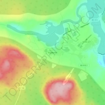
Name: Vuollerim topographic map, elevation, terrain.

Location: Vuollerim, Jokkmokks kommun, Norrbotten County, Sweden (66.40956 20.58242 66.44956 20.62242)

Average elevation: 127 m

Minimum elevation: 52 m

Maximum elevation: 240 m

Gear up for your next adventure:

Tent Footprint - Protect tent floor and increase durability
🛰️Satellite Messenger - Emergency communication for areas with no cell service
🔦LED Flashlight - Powerful and long-lasting flashlight for camping and emergencies
🥾Hiking Shoes - Durable and comfortable shoes for trail hiking
🔪Outdoor Multitool - Versatile tool for repairs and food prep in the wild

As an Amazon Associate, this site earns from qualifying purchases at no extra cost to you.