Geolocate

Reims topographic map

Click on the map to display elevation.

About this map

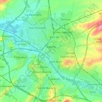
Name: Reims topographic map, elevation, terrain.

Location: Reims, Marne, Grand Est, Metropolitan France, 51100, France (49.20394 3.98582 49.30319 4.12970)

Average elevation: 96 m

Minimum elevation: 70 m

Maximum elevation: 166 m

Gear up for your next adventure:

🥾Trail Hiking Socks - Comfortable socks to prevent blisters and fatigue
🎒Hiking Daypack - Lightweight and durable backpacks for day trips and excursions
🛌Down Sleeping Bag - Superior warmth-to-weight ratio for cold nights
🦶Hiking Shoe Insoles - Added support for high arches and long days on feet
🔦LED Flashlight - Powerful and long-lasting flashlight for camping and emergencies

As an Amazon Associate, this site earns from qualifying purchases at no extra cost to you.