
Es Cubells topographic map
Click on the map to display elevation.
About this map
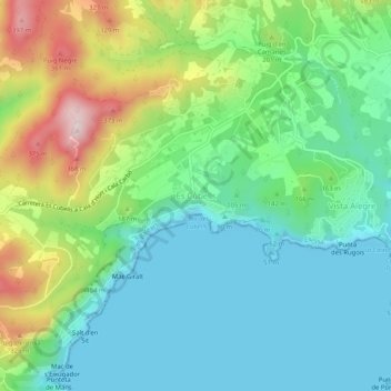
Name: Es Cubells topographic map, elevation, terrain.
Average elevation: 124 m
Minimum elevation: 0 m
Maximum elevation: 419 m
Other topographic maps
Click on a map to view its topography, its elevation and its terrain.
Paseo Marítimo de la Bahia de Sant Antoni de Portmany
Spain > Balearic Islands > Ibiza > Sant Antoni de Portmany
Average elevation: 11 m
Cala Grassio
Spain > Balearic Islands > Ibiza > Sant Antoni de Portmany > Can Germà > Cap Negret
Average elevation: 23 m