
Chiddes topographic map
Interactive map
Click on the map to display elevation.
About this map
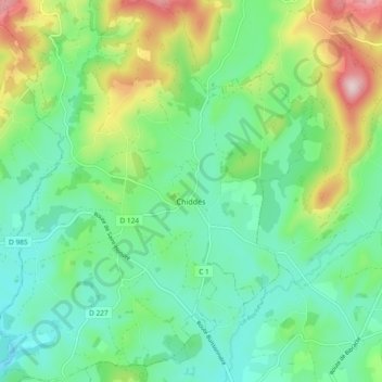
Name: Chiddes topographic map, elevation, terrain.
Average elevation: 341 m
Minimum elevation: 245 m
Maximum elevation: 571 m
Le village est situé sur les dernières pentes méridionales du Morvan (le mont Thouleur, Montjouan, le mont Genièvre sont visibles de Chiddes) et est dominé par le mont Charlet, qui possède à son sommet un petit monument religieux en béton et une table d'orientation. Le bourg est à 317 mètres d'altitude, mais le finage communal s'échelonne entre 515 mètres et 244 mètres pour une altitude moyenne de 380 mètres[2]. Du bourg, la vue s'étend loin aussi vers le sud.
Other topographic maps
Click on a map to view its topography, its elevation and its terrain.
Pouilly-sur-Loire
France > Bourgogne-Franche-Comté > Nièvre
Pouilly-sur-Loire, Cosne-Cours-sur-Loire, Nièvre, Bourgogne-Franche-Comté, France métropolitaine, 58150, France
Average elevation: 175 m
Toury-Lurcy
France > Bourgogne-Franche-Comté > Nièvre
Toury-Lurcy, Nevers, Nièvre, Bourgogne-Franche-Comté, France métropolitaine, 58300, France
Average elevation: 225 m
Soulange
France > Bourgogne-Franche-Comté > Nièvre > Beaumont-Sardolles
Soulange, Beaumont-Sardolles, Nevers, Nièvre, Bourgogne-Franche-Comté, France métropolitaine, 58270, France
Average elevation: 254 m
Lac Gauthier
France > Bourgogne-Franche-Comté > Nièvre > Champlemy
Lac Gauthier, Champlemy, Cosne-Cours-sur-Loire, Nièvre, Bourgogne-Franche-Comté, France métropolitaine, 58210, France
Average elevation: 293 m
Préporché
France > Bourgogne-Franche-Comté > Nièvre
Préporché, Château-Chinon (Ville), Nièvre, Bourgogne-Franche-Comté, France métropolitaine, 58360, France
Average elevation: 313 m
Montboblin
France > Bourgogne-Franche-Comté > Nièvre > Alligny-en-Morvan > Montboblin
Montboblin, Alligny-en-Morvan, Château-Chinon (Ville), Nièvre, Bourgogne-Franche-Comté, France métropolitaine, 58230, France
Average elevation: 620 m
Bois du Vernat
France > Bourgogne-Franche-Comté > Nièvre > Brassy > Montchelnot
Bois du Vernat, Montchelnot, Brassy, Château-Chinon (Ville), Nièvre, Bourgogne-Franche-Comté, France métropolitaine, 58140, France
Average elevation: 484 m
Arzembouy
France > Bourgogne-Franche-Comté > Nièvre > Arzembouy
Arzembouy, Cosne-Cours-sur-Loire, Nièvre, Bourgogne-Franche-Comté, France métropolitaine, 58700, France
Average elevation: 305 m
Aunay-en-Bazois
France > Bourgogne-Franche-Comté > Nièvre > Aunay-en-Bazois
Aunay-en-Bazois, Château-Chinon (Ville), Nièvre, Bourgogne-Franche-Comté, France métropolitaine, 58110, France
Average elevation: 284 m
Nevers
France > Bourgogne-Franche-Comté > Nièvre > Nevers
Nevers, Nièvre, Bourgogne-Franche-Comté, France métropolitaine, 58000, France
Average elevation: 187 m
Marcy
France > Bourgogne-Franche-Comté > Nièvre
Marcy, Clamecy, Nièvre, Bourgogne-Franche-Comté, France métropolitaine, 58210, France
Average elevation: 266 m
Chaumard
France > Bourgogne-Franche-Comté > Nièvre > Chaumard
Chaumard, Château-Chinon (Ville), Nièvre, Bourgogne-Franche-Comté, France métropolitaine, 58120, France
Average elevation: 422 m
Château-Chinon (Ville)
France > Bourgogne-Franche-Comté > Nièvre
Château-Chinon (Ville), Nièvre, Bourgogne-Franche-Comté, France métropolitaine, 58120, France
Average elevation: 470 m