
Make a donation
Gear up for your next adventure:
As an Amazon Associate, this site earns from qualifying purchases at no extra cost to you.
Pomacle topographic map
Click on the map to display elevation.
Make a donation
Gear up for your next adventure:
As an Amazon Associate, this site earns from qualifying purchases at no extra cost to you.
Pomacle
L’occupation du territoire de Pomacle est fort ancienne comme le révèle les fouilles archéologiques réalisées sur son terroir. D’après le Dictionnaire topographique de la Marne, le vocable de « Pomacle » est attesté pour la première fois en 1145 dans les archives administratives de la ville de Reims (Pomaclum)[8]. Il s’agit d’une bulle du pape Eugène III confirmant le privilège d’immunité pour l’abbaye de Saint-Remi de Reims et pour ses dépendances.
Make a donation
Gear up for your next adventure:
As an Amazon Associate, this site earns from qualifying purchases at no extra cost to you.
About this map
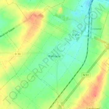
Name: Pomacle topographic map, elevation, terrain.
Average elevation: 98 m
Minimum elevation: 79 m
Maximum elevation: 123 m
Make a donation
Gear up for your next adventure:
As an Amazon Associate, this site earns from qualifying purchases at no extra cost to you.
Other topographic maps
Click on a map to view its topography, its elevation and its terrain.
Make a donation
Gear up for your next adventure:
As an Amazon Associate, this site earns from qualifying purchases at no extra cost to you.