Geolocate

Vienna topographic map

Click on the map to display elevation.

About this map

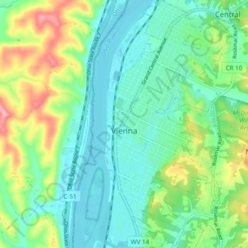
Name: Vienna topographic map, elevation, terrain.

Location: Vienna, Wood County, West Virginia, 25105, United States (39.29602 -81.55644 39.34854 -81.50730)

Average elevation: 214 m

Minimum elevation: 178 m

Maximum elevation: 300 m

Other topographic maps

Click on a map to view its topography, its elevation and its terrain.

Deerwalk

United States > West Virginia > Wood County

Average elevation: 282 m

Belleville

United States > West Virginia > Wood County

Average elevation: 207 m

Lee Creek

United States > West Virginia > Wood County

Average elevation: 205 m

Slate

United States > West Virginia > Wood County

Average elevation: 225 m

Ogden

United States > West Virginia > Wood County

Average elevation: 249 m

Gear up for your next adventure:

🧥Packable Rain Jacket - Breathable waterproof layer for unpredictable weather
🧼Travel Hand Sanitizer - Keep hands clean when water is scarce
🧰Survival Kit - Essential gear for emergencies in the wilderness
🥾Hiking Leggings - Comfortable leggings for outdoor activities
🧥Thermal Fleece Jacket - Versatile insulation for changing mountain temperatures

As an Amazon Associate, this site earns from qualifying purchases at no extra cost to you.