
Town of Gouverneur topographic map
Interactive map
Click on the map to display elevation.
About this map
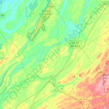
Name: Town of Gouverneur topographic map, elevation, terrain.
Average elevation: 138 m
Minimum elevation: 83 m
Maximum elevation: 248 m
Other topographic maps
Click on a map to view its topography, its elevation and its terrain.
Sister Island
United States > New York > Saint Lawrence County > Town of Hammond
Sister Island, Town of Hammond, Saint Lawrence County, New York, United States
Average elevation: 113 m
Cranberry Lake
United States > New York > Saint Lawrence County
Cranberry Lake, Town of Clifton, Saint Lawrence County, New York, 12927, United States
Average elevation: 479 m
Singer Castle
United States > New York > Saint Lawrence County > Town of Hammond
Singer Castle, 1, Chippewa Point Road, Town of Hammond, Saint Lawrence County, New York, 13646, United States
Average elevation: 73 m
Village of Canton
United States > New York > Saint Lawrence County
Village of Canton, Town of Canton, Saint Lawrence County, New York, United States
Average elevation: 115 m
Cranberry Lake
United States > New York > Saint Lawrence County > Cranberry Lake
Cranberry Lake, Saint Lawrence County, New York, 12927, United States
Average elevation: 472 m