Geolocate

Surla topographic map

Click on the map to display elevation.

About this map

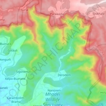
Name: Surla topographic map, elevation, terrain.

Location: Surla, Nanorem, Satari, North Goa, Goa, 591345, India (15.56203 74.18165 15.68042 74.21944)

Average elevation: 384 m

Minimum elevation: 39 m

Maximum elevation: 950 m

Gear up for your next adventure:

Family Camping Tent - Spacious tent suitable for family camping trips
🚲Bike Repair Kit - Essential tools for on-trail mechanical issues
Backpacking Tent - Lightweight tent for long-distance hiking trips
🔋Solar Power Bank - Keep your GPS and devices charged during long outdoor trips
🛏️Sleeping Bag - Warm and compact sleeping bags for outdoor camping

As an Amazon Associate, this site earns from qualifying purchases at no extra cost to you.