Geolocate

Nagari topographic map

Click on the map to display elevation.

About this map

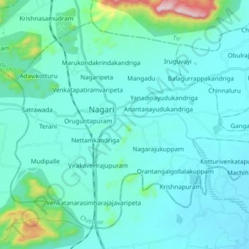
Name: Nagari topographic map, elevation, terrain.

Location: Nagari, Chittoor, Andhra Pradesh, 517590, India (13.25704 79.53518 13.36772 79.67199)

Average elevation: 151 m

Minimum elevation: 73 m

Maximum elevation: 760 m

Other topographic maps

Click on a map to view its topography, its elevation and its terrain.

Mangadu

India > Andhra Pradesh > Nagari > Mangadu

Average elevation: 117 m

Gear up for your next adventure:

🪑Ultralight Camping Stool - Compact seating for rest stops during long hikes
🐕Hiking Dog Pack - Let your canine companion carry their own water and food
🌡️Emergency Mylar Blankets - Compact thermal protection for unexpected nights outdoors
🔦LED Headtorch - Bright and durable light for night activities
🧦Outdoor Socks - Durable socks designed for hiking and outdoor sports

As an Amazon Associate, this site earns from qualifying purchases at no extra cost to you.