Geolocate

Tierradentro topographic map

Click on the map to display elevation.

About this map

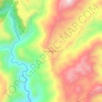
Name: Tierradentro topographic map, elevation, terrain.

Location: Tierradentro, Nevados, Tolima, Colombia (4.84480 -75.02959 4.88480 -74.98959)

Average elevation: 1,125 m

Minimum elevation: 751 m

Maximum elevation: 1,484 m

Gear up for your next adventure:

🌡️Emergency Mylar Blankets - Compact thermal protection for unexpected nights outdoors
🥾Trail Hiking Shoes - Durable shoes designed for rugged trails
🧭GPS Tracker - Track your location in remote areas safely
Tent Footprint - Protect tent floor and increase durability
🧤Rechargeable Heated Gloves - Extreme warmth for Canadian winter expeditions

As an Amazon Associate, this site earns from qualifying purchases at no extra cost to you.