
Thank you for supporting this site ❤️
Make a donation
Make a donation
Gear up for your next adventure:
As an Amazon Associate, this site earns from qualifying purchases at no extra cost to you.
Accopujio topographic map
Click on the map to display elevation.
Thank you for supporting this site ❤️
Make a donation
Make a donation
Gear up for your next adventure:
As an Amazon Associate, this site earns from qualifying purchases at no extra cost to you.
About this map
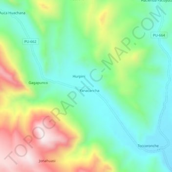
Name: Accopujio topographic map, elevation, terrain.
Location: Accopujio, Nuñoa, Melgar, Puno, Perú (-14.38894 -70.62627 -14.34894 -70.58627)
Average elevation: 4,332 m
Minimum elevation: 4,127 m
Maximum elevation: 4,713 m
Thank you for supporting this site ❤️
Make a donation
Make a donation
Gear up for your next adventure:
As an Amazon Associate, this site earns from qualifying purchases at no extra cost to you.