
Make a donation
Gear up for your next adventure:
As an Amazon Associate, this site earns from qualifying purchases at no extra cost to you.
Temploux topographic map
Click on the map to display elevation.
Make a donation
Gear up for your next adventure:
As an Amazon Associate, this site earns from qualifying purchases at no extra cost to you.
About this map
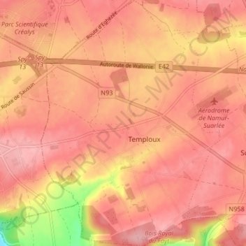
Name: Temploux topographic map, elevation, terrain.
Location: Temploux, Namur, Wallonie, 5020, Belgique (50.46458 4.72305 50.50678 4.77125)
Average elevation: 169 m
Minimum elevation: 109 m
Maximum elevation: 205 m
Make a donation
Gear up for your next adventure:
As an Amazon Associate, this site earns from qualifying purchases at no extra cost to you.
Other topographic maps
Click on a map to view its topography, its elevation and its terrain.
Namur
Belgique > Namur > Namur > Namur
Le cours de la Meuse moyenne s'est développé dans une vallée en auge, bordée par de hautes falaises calcaires, nettement visibles en amont (Dave) et en aval (Marche-les-Dames) de Namur. La Sambre paresse quant à elle dans des plaines au relief plus faiblement marqué, y décrivant de larges boucles. Au…
Average elevation: 185 m