Geolocate

Kothur topographic map

Click on the map to display elevation.

About this map

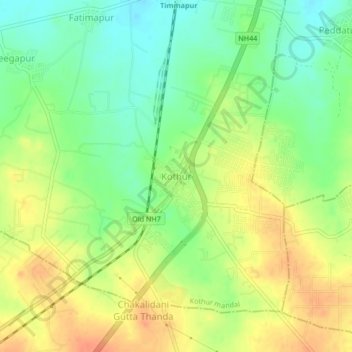
Name: Kothur topographic map, elevation, terrain.

Location: Kothur, Kothur mandal, Rangareddy, Telangana, 509228, India (17.12861 78.26869 17.16861 78.30869)

Average elevation: 593 m

Minimum elevation: 572 m

Maximum elevation: 614 m

Gear up for your next adventure:

🥾Mountain Trail Shoes - High-traction shoes for mountain trails
🥾Mountain Hiking Shoes - Shoes with superior grip for mountainous terrain
🧥Insulated Jacket - Keep warm in cold outdoor conditions
Backpacking Tent - Lightweight tent for long-distance hiking trips
📷Outdoor Action Camera - Capture high-elevation views and rugged adventures

As an Amazon Associate, this site earns from qualifying purchases at no extra cost to you.