
Make a donation
Gear up for your next adventure:
As an Amazon Associate, this site earns from qualifying purchases at no extra cost to you.
Welldorf topographic map
Click on the map to display elevation.
Make a donation
Gear up for your next adventure:
As an Amazon Associate, this site earns from qualifying purchases at no extra cost to you.
Welldorf
Im Westen liegt Lich-Steinstraß, im Norden Spiel (Gemeinde Titz), im Osten Güsten und im Süden der Tagebau Hambach mit der Sophienhöhe. Die Bebauung von Güsten und Welldorf geht fast nahtlos ineinander über.
Make a donation
Gear up for your next adventure:
As an Amazon Associate, this site earns from qualifying purchases at no extra cost to you.
About this map
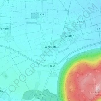
Name: Welldorf topographic map, elevation, terrain.
Location: Welldorf, Jülich, Kreis Düren, Nordrhein-Westfalen, Deutschland (50.92730 6.39360 50.96950 6.44405)
Average elevation: 121 m
Minimum elevation: 87 m
Maximum elevation: 291 m
Make a donation
Gear up for your next adventure:
As an Amazon Associate, this site earns from qualifying purchases at no extra cost to you.
Other topographic maps
Click on a map to view its topography, its elevation and its terrain.
Forsthaus Stetternich
Deutschland > Nordrhein-Westfalen > Kreis Düren > Jülich > Lich-Steinstraß
Average elevation: 93 m
Make a donation
Gear up for your next adventure:
As an Amazon Associate, this site earns from qualifying purchases at no extra cost to you.
Brückenkopfpark
Deutschland > Nordrhein-Westfalen > Kreis Düren > Jülich > Koslar
Der Brückenkopf ist als Kronwerk ausgelegt und weist eine Breite von etwa 800 Metern, eine Tiefe von etwa 300 Metern und eine Höhe von etwa zehn Metern auf. Er besteht im Wesentlichen aus mit Mauern abgestütztem Erdreich. Auf dem Wall befinden sich tonnengewölbte Hohltraversen zur Aufstellung von…
Average elevation: 83 m