Geolocate

Laurel topographic map

Click on the map to display elevation.

About this map

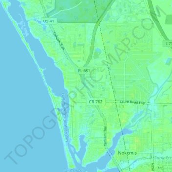
Name: Laurel topographic map, elevation, terrain.

Location: Laurel, Sarasota County, Florida, United States (27.11215 -82.48712 27.17606 -82.43567)

Average elevation: 3 m

Minimum elevation: -2 m

Maximum elevation: 10 m

Gear up for your next adventure:

🏃Hydration Running Vest - Carry water and maps close to your body for speed
🧢Hiking Hat - Sun-protective and breathable hats for long treks
🥾Mountain Hiking Shoes - Shoes with superior grip for mountainous terrain
🔥Emergency Fire Starter - Reliable ignition source for all weather conditions
🎒Fully Waterproof Backpack - Total protection for photography gear and electronics

As an Amazon Associate, this site earns from qualifying purchases at no extra cost to you.