Geolocate

Castellone topographic map

Click on the map to display elevation.

About this map

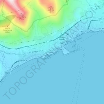
Name: Castellone topographic map, elevation, terrain.

Location: Castellone, Formia, Latina, Lazio, 04023, Italy (41.23234 13.58133 41.27234 13.62133)

Average elevation: 83 m

Minimum elevation: -2 m

Maximum elevation: 644 m

Gear up for your next adventure:

🥫Freeze-Dried Meals - Lightweight, high-calorie nutrition for multi-day treks
🦯Trekking Poles - Reduced impact on joints for steep topographic climbs
🧣Merino Neck Gaiter - Protects against wind, sun, and cold at high altitudes
🧊Insulated Water Bottle - Keeps drinks cold in summer and prevents freezing in winter
Lightweight Camping Tent - Portable shelter optimized for Canadian backcountry camping

As an Amazon Associate, this site earns from qualifying purchases at no extra cost to you.