Geolocate

Cesar topographic map

Click on the map to display elevation.

About this map

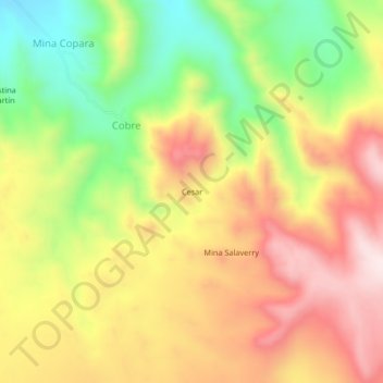
Name: Cesar topographic map, elevation, terrain.

Location: Cesar, Marcona, Nasca, Ica, Perú (-15.07278 -74.91412 -15.03278 -74.87412)

Average elevation: 973 m

Minimum elevation: 718 m

Maximum elevation: 1,207 m

Other topographic maps

Click on a map to view its topography, its elevation and its terrain.

Bahía San Juan

Perú > Ica > Marcona

Average elevation: 40 m

Gear up for your next adventure:

🩹Compact First Aid Kit - Pre-packed essentials for common trail injuries
🥫Freeze-Dried Meals - Lightweight, high-calorie nutrition for multi-day treks
🔭Compact Binoculars - Lightweight optics for scouting trails and wildlife
👟Trail Running Shoes - Agile footwear for fast-paced topographic exploration
🥾Lightweight Hiking Shoes - Comfortable shoes for day hikes

As an Amazon Associate, this site earns from qualifying purchases at no extra cost to you.