Geolocate

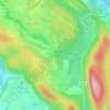
Billieu topographic map

Click on the map to display elevation.

About this map

Name: Billieu topographic map, elevation, terrain.

Location: Billieu, Magnieu, Belley, Ain, Auvergne-Rhône-Alpes, France métropolitaine, 01300, France (45.76876 5.68689 45.80876 5.72689)

Average elevation: 319 m

Minimum elevation: 225 m

Maximum elevation: 493 m

Other topographic maps

Click on a map to view its topography, its elevation and its terrain.
Saint-Champ

France > Auvergne-Rhône-Alpes > Ain > Magnieu

Average elevation: 348 m

Gear up for your next adventure:

🕶️Polarized Sunglasses - Protect your eyes with durable polarized lenses
🥾Trail Hiking Boots - Supportive boots for rough trails
⛺Lightweight Camping Tent - Portable shelter optimized for Canadian backcountry camping
⛺Family Camping Tent - Spacious tent suitable for family camping trips
🥾Durable Hiking Shoes - Long-lasting shoes for frequent hiking

As an Amazon Associate, this site earns from qualifying purchases at no extra cost to you.