
Yamkeshwar topographic map
Click on the map to display elevation.
About this map
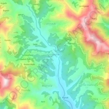
Name: Yamkeshwar topographic map, elevation, terrain.
Location: Yamkeshwar, Pauri Garhwal, Uttarakhand, 246121, India (29.95626 78.39828 29.99626 78.43828)
Average elevation: 1,077 m
Minimum elevation: 862 m
Maximum elevation: 1,435 m
Other topographic maps
Click on a map to view its topography, its elevation and its terrain.
Elephant Pound Rajaji National park Uttrakhand
India > Uttarakhand > Yamkeshwar
Average elevation: 455 m
Elephant Pound Rajaji National park Uttrakhand
India > Uttarakhand > Yamkeshwar
Average elevation: 455 m
Elephant Pound Rajaji National park Uttrakhand
India > Uttarakhand > Yamkeshwar
Average elevation: 455 m
Elephant Pound Rajaji National park Uttrakhand
India > Uttarakhand > Yamkeshwar
Average elevation: 455 m
Elephant Pound Rajaji National park Uttrakhand
India > Uttarakhand > Yamkeshwar
Average elevation: 455 m