Geolocate

Joppolo topographic map

Click on the map to display elevation.

About this map

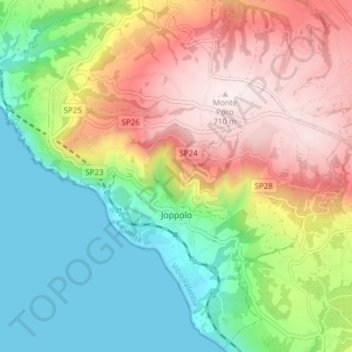
Name: Joppolo topographic map, elevation, terrain.

Location: Joppolo, Vibo Valentia, Calabria, 89863, Italy (38.56091 15.85669 38.61973 15.93285)

Average elevation: 286 m

Minimum elevation: 0 m

Maximum elevation: 710 m

Other topographic maps

Click on a map to view its topography, its elevation and its terrain.

Caroniti

Italy > Calabria > Vibo Valentia > Joppolo

Average elevation: 419 m

Punta Safò

Italy > Calabria > Vibo Valentia > Briatico

Average elevation: 15 m

Arzona

Italy > Calabria > Vibo Valentia

Average elevation: 450 m

Gear up for your next adventure:

🎒Backpack Rain Cover - External shield to keep your entire pack dry
🥽Outdoor Goggles - Protective eyewear for outdoor activities
🕯️Camping Lantern - Illuminates your entire campsite with high-efficiency LEDs
🥾Hiking Shorts - Breathable shorts suitable for summer hikes
🥾Trail Hiking Shoes - Durable shoes designed for rugged trails

As an Amazon Associate, this site earns from qualifying purchases at no extra cost to you.