

Pleißa topographic map
Click on the map to display elevation.
Pleißa
In der Meißener Jurisdiktionsmatrikel wird Steinplissen im Jahre 1346 zum ersten Mal als Kirchdorf genannt. Der Name leitet sich vom Pleißenbach ab, welcher auf der Langenberger Höhe entspringt und in Chemnitz in der Nähe des Schlossteichs in die Chemnitz mündet. Das Wort [Stein-]plissen stammt vom sorbischen plisni zu *plisa ab, was die Bedeutung von ‚Pfütze, Tümpel‘ oder ‚Sumpf‘ hat.
About this map
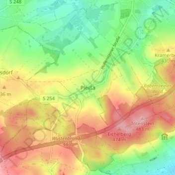
Name: Pleißa topographic map, elevation, terrain.
Average elevation: 413 m
Minimum elevation: 351 m
Maximum elevation: 480 m
Other topographic maps
Click on a map to view its topography, its elevation and its terrain.

FFH Mittleres Zwickauer Muldetal (Teilfläche 4: Wiese bei Bräunsdorf)
Deutschland > Sachsen > Zwickau > Limbach-Oberfrohna > Bräunsdorf
Average elevation: 326 m
