
Make a donation
Gear up for your next adventure:
As an Amazon Associate, this site earns from qualifying purchases at no extra cost to you.
Lac de la Mine topographic map
Click on the map to display elevation.
Make a donation
Gear up for your next adventure:
As an Amazon Associate, this site earns from qualifying purchases at no extra cost to you.
About this map
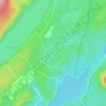
Name: Lac de la Mine topographic map, elevation, terrain.
Location: Lac de la Mine, Orford, Memphrémagog, Estrie, Québec, Canada (45.42040 -72.19747 45.42435 -72.19303)
Average elevation: 321 m
Minimum elevation: 267 m
Maximum elevation: 470 m
Make a donation
Gear up for your next adventure:
As an Amazon Associate, this site earns from qualifying purchases at no extra cost to you.
Other topographic maps
Click on a map to view its topography, its elevation and its terrain.
Mont Orford
Canada > Québec > Memphrémagog > Orford
Le mont Orford, situé dans la municipalité de canton d'Orford, Québec, Canada, près de Magog, fait partie des monts Sutton et s'élève à 853 mètres d'altitude. Il fait partie du parc national du Mont-Orford. Il est aussi l'une des montagnes skiables les plus élevées du Québec.
Average elevation: 559 m
Make a donation
Gear up for your next adventure:
As an Amazon Associate, this site earns from qualifying purchases at no extra cost to you.
Mont Orford
Canada > Québec > Memphrémagog > Orford
Le mont Orford, montagne située dans la municipalité de canton d'Orford, Québec, Canada, près de Magog, fait partie des monts Sutton et s'élève à 853 mètres d'altitude. Il fait partie du parc national du Mont-Orford. Il est aussi l'une des montagnes skiables les plus élevées du Québec.
Average elevation: 559 m