Geolocate

Fort Point topographic map

Click on the map to display elevation.

About this map

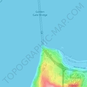
Name: Fort Point topographic map, elevation, terrain.

Location: Fort Point, Golden Gate Bridge East Sidewalk, San Francisco, CAL Fire Northern Region, California, 94129, United States (37.81015 -122.47759 37.81086 -122.47662)

Average elevation: 10 m

Minimum elevation: -11 m

Maximum elevation: 117 m

Other topographic maps

Click on a map to view its topography, its elevation and its terrain.

Mount Davidson

United States > California > San Francisco

Mount Davidson is the highest natural point in San Francisco, California, with an elevation of 928 feet (283 m). It is located near the geographical center of the city, south of Twin Peaks and Portola Drive and to the west of Diamond Heights and Glen Park. It dominates the southeastern view from most of…

Average elevation: 138 m

Larsen Peak

United States > California > San Francisco

Average elevation: 138 m

Twin Peaks

United States > California > San Francisco

Average elevation: 143 m

Potrero Hill

United States > California > San Francisco

Average elevation: 17 m

Gear up for your next adventure:

🛌Insulated Sleeping Pad - Critical thermal barrier between you and the cold ground
🚲Heavy Duty Bike Lock - Secure your bike at the trailhead or during stops
🧥Softshell Hiking Jacket - The perfect balance of wind protection and breathability
🧭GPS Tracker - Track your location in remote areas safely
🔨Vehicle Emergency Tool - Safety tool for remote road trips to trailheads

As an Amazon Associate, this site earns from qualifying purchases at no extra cost to you.